
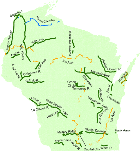
Wisconsin State Trails
Wisconsin has 37 state trails totaling 1,607 miles. They have a variety of surfaces, summer and winter, for a variety of activities--walking/hiking, bicycling, in-line skating, horseback and all-terrain vehicle riding, snowmobiling, cross-country skiing, and snowshoeing.
A 22-mile rail bed trail between Elroy and Reedsburg. Connects to the Elroy-Sparta, Hillsboro, and Omaha Trails. Features rock outcroppings along the Baraboo River. Hike, touring bike, snowmobile. C/o P.O. Box 99, Ontario 54651. (608) 337-4775 or (608) 524-2850. Back to map
From downtown Sturgeon Bay, the county-operated trail winds south and west 30 miles along the beautiful Ahnapee River to Algoma and Casco in Kewaunee County. Hike, touring bike, ski, snowmobile. C/o , 3538 Park Drive, Sturgeon Bay 54235, (920) 746-9959, or c/o Courthouse, 613 Dodge St., Kewaunee 54216, (920) 388-4410. Back to map
This trail, on a former rail grade, will connect Madison with Freeport, Illinois. It will go through Belleville and Monroe and connect with the Capital City, Ice Age, and Sugar River trails. There is a tunnel south of Belleville.Only the portion within the City of Madison, known as the Southwest Path, has been completed. C/o W5446, County Trunk Highway NN, New Glarus 53574. (608) 527-2335.. Back to map
Bearskin-Hiawatha State Trail
Two trails on a former rail bed between Minocqua and Tomahawk. The Bearskin runs 18.3 miles south from Minocqua; the Hiawatha runs north from Tomahawk 6 miles. Hike, touring bike, snowmobile. C/o 518 W. Somo Ave., Tomahawk 54487, (715) 453-1263. Back to map
A 36.4-mile multi-use trail between Mondovi and Fairchild in west-central Wisconsin. Passes farms, woods, hills, marsh and the Buffalo River. Hike or ride a mountain bike, horse, all-terrain vehicle (ATV) or snowmobile. C/o P.O. Box 407, Trempealeau 54661-0407. (608) 534-6409. Back to map
About 17 miles of this trail are completed, through the east side of Madison, along Lake Monona, and through the scenic Capital Springs State Recreation Area (Dane County E-way) south of Madison. It connects with the Military Ridge State Trail and city bikeways. Its asphalt surface is good for bicycling, walking, jogging, and in-line skating. (State portion) 3101 Lake Farm Road, Madison, WI 53711. (608) 224-3606; (city portion) c/o Madison Department of Transportation, P.O. Box 2986, Madison 53701-2986, (608) 266-6225. Back to map
This county-operated trail extends 17.8 miles surrounded by forests, farmlands,ponds, and meadows in the gently rolling hills of western Wisconsin. Observe a variety of birds and wildlife from the rustic abandoned railroad grade. C/o Barron County, 1418 E. LaSalle Ave., Barron 54812, (715) 637-4275. Back to map
A 20-mile trail linking Eau Claire with the Red Cedar Trail. The five miles adjacent to Eau Claire are paved for in-line skaters. River and rural scenery. Hike, touring bike, ski, snowmobile. C/o DNR, 1300 W. Clairemont Ave. P.O. Box 4001, Eau Claire 54702. (715) 839-1607. Back to map
A delightful, 32.5-mile ride that includes three century-old railway tunnels and a succession of friendly, small towns. Hike, touring bike, snowmobile. C/o P.O. Box 99, Ontario 54651. (608) 337-4775 or (608) 463-7109. Back to map
A new 13.5-mile county-operated multiple-use state recreation trail between Green Bay and Greenleaf. It has a swing bridge over the Fox River at the north end of the trail. From the trailhead, approximately 5.4 miles of the urban section of the trail is asphalt-paved. The southern portion of the trail south of Heritage Road allows horseback riding on bridle paths along side the trail corridor. C/o Brown County, 305 E. Walnut St., Green Bay 54301, (920) 448-4466.Back to map
This new county-operated state trail goes through agricultural lands between Brillion and Forest Junction. It goes near the . C/o Calumet County Parks, N6150 County Trunk E, Hilbert 54129, (920) 439-1008. Back to map
This county-operated 98-mile multi-use trail crosses the Wisconsin/Minnesota border twice on its way from St. Croix Falls to Superior. A highlight is the 520-foot bridge over the scenic St. Croix River near Danbury. Hike, touring bike, mountain bike, ski, snowmobile (Polk County Parks & Recreation 100 Polk Plaza #10, Balsam Lake 54810. (715) 485-9272 Douglas County Forestry Dept. P.O. Box 211, Solon Springs 54873. (715) 378-2219 or c/o Burnett County Parks 7410 County Road K #106, Siren 54872. (715) 349-2157. Back to map
A 51-mile ride through glacial landscapes between Waukesha and Cottage Grove. There is a 4-mile on-road stretch at the mid-point near Jefferson. The 13 miles nearest Waukesha are paved for in-line skaters. Hike, touring bike, ski, snowmobile. 68, east, c/o W329 N846 County Hwy. C, Delafield 53018, (262) 646-3025; 69, west, 1213 S. Main St., Lake Mills 53551, (920) 648-8774. Back to map
This 24-mile rail bed trail winds its way through the Mississippi River bottom lands north from Onalaska through Trempealeau, Perrot State Park, and the Trempealeau National Wildlife Refuge. Hike, touring bike, ski, snowmobile. C/o P.O. Box 407, Trempealeau 54661. (608) 534-6409. Back to map
The Stevens Point area's locally-operated 24-mile nature trail circles through river shores, trees, plants, wild birds, and animals. Recall the history of the huge pinery, Indian camps, pioneer settlements, and lore of the Wisconsin and Plover rivers. Hike, touring bike, ski. 1462 Strongs Ave., Stevens Point 54481. (715) 346-1433. Back to map
This trail will include multi-purpose trails and riverwalks along the lower Menomonee river in Milwaukee. The trail is under construction. Rideable segments are from Doyne Park into the stadium area and another segment between 25th and 13th streets along the Menomonee River.C/o DNR, 2300 N. Martin Luther King Jr. Dr., Milwaukee 53212. (414) 263-8559. Back to map
A 4.3-mile county-operated hike/bike/snowmobile trail between Hillsboro and the 400 Trail at Union Center. Hike, touring bike, ski, snowmobile. c/o Vernon County Forestry/Parks, 220 Airport Rd., Viroqua 54665, (608) 637-5485, or Juneau Co. Forestry & Parks 250 Oak St., Mauston 53948-1365, (608) 489-2350. Back to map
A national and state scenic trail, 1,000 miles when completed, located entirely in Wisconsin. The purpose of the trail is to tell the story of the Ice Age and continental glaciation along a scenic footpath. Segments of the trail in four units of the Kettle Moraine State Forest and the Chequamegon National Forest, and many shorter stretches are open. c/o Ice Age Park and Trail Foundation, 207 East Buffalo St. #515, Milwaukee 53202-5712, (262) 278-8518 or (800) 227-0046. Back to map
A delightful 24.5-mile ride along the La Crosse River between Sparta and La Crosse. The trail is a middle link between the Elroy-Sparta Trail and the Great River Trail. Hike, touring bike, snowmobile. C/o P.O. Box 99, Ontario 54651. (608) 337-4775 or (608) 269-4123. Back to map
This 9-mile trail goes past farms and wetlands and the communities of Ripon and Berlin. Hike, horse, mountain bike, snowmobile. C/o Fond du Lac County Planning & Parks, 160 S. Macy St., Fond du Lac 54935, (920) 929-3135; Green Lake County, 492 Hill St., Green Lake 54941, (920) 294-4032; or Winnebago County Parks, 625 E. County Rd. Y #500, Oshkosh 54901-8131, (920) 232-1960. Back to map
The 41-mile trail between Madison and Dodgeville follows an old military road built in 1855. Rich in history and panoramic views. Hike or bike on the entire trail; also in-line skate on the 3 miles between Madison and Verona and snowmobile on the rest. 4350 Mounds Park Rd, P.O.Box 98, Blue Mounds 53517-0098. (608) 437-7393). Back to map
A county-operated 80.5-mile rail bed trail that passes through a wide variety of landscapes between the Wausau and Green Bay areas. Many bridges. Trail users must use streets and roads through Shawano. Hike, touring bike, snowmobile. C/o Wausau/Marathon County Parks, Courthouse, 500 Forest St., Wausau 54403, (715) 261-1515; Shawano County Parks Dept., 311 N. Main St., Shawano 54166, (715) 526-6766; or Brown County Park Dept., 305 E. Walnut St. #304, Green Bay 54301, (920) 448-4466. Back to map
A county-operated 44.5-mile former rail corridor through forests and farms of northeast Wisconsin. The northern half is surrounded by the Nicolet National Forest. C/o Oconto County Land Office, 300 Washington St., Oconto 54153, (920) 834-6995. Back to map
When completed, this national hiking and backpacking trail will extend 4,000 miles across seven northern states. In Wisconsin, there are about 75 miles of completed segments in Iron County Forest, Copper Falls State Park and the Chequamegon National Forest. c/o National Park Service, 700 Rayovac Dr., Madison 53711, (608) 264-5610. Back to map
A county-operated 18-mile trail between Oconto and Stiles junction. It goes near Copper Culture State Park. The trail parallels the Oconto River, a popular water for float trips and fishing. You can float part of the river an hike or bike back on the trail. Back to map
A scenic corridor following the Chippewa River through agricultural and undeveloped lands and along the Chippewa River between Lake Wissota State Park and Brunet Island State Park at Cornell. A parallel horse trail connects Jim Falls and Lake Wissota State Park. Hike, touring bike, snowmobile. C/o Chippewa County Forest and Parks, 711 N. Bridge St., Chippewa Falls 54729. (715) 726-7880. Back to map
Running 10 miles through the picturesque Bonner Branch Valley, this county-operated trail links Belmont with Calamine and the 47-mile multi-use Cheese Country Trail. Hike, touring bike, ski, snowmobile. C/o Green County Courthouse 1016 16th Ave., Monroe 53566. (608) 328-9430. Back to map
The trail shadows the steep walls of the Red Cedar Valley 14.5 miles from Menomonie to the Chippewa River Valley. Wildlife along the trail includes pileated woodpeckers, songbirds, turkey, grouse, pheasants, fox, and deer. Connects to the 20-mile Chippewa River Trail. Hike, touring bike, ski, snowmobile, snowshoe. 921 Brickyard Rd., Menomonie 54751. (715) 232-1242. Back to map
This 8.4-mile county-operated trail links with the Gandy Dancer Trail near Superior and continues into Minnesota. Hike, mountain bike, ski, snowmobile. C/o Douglas County Forestry Dept., P.O. Box 211, Solon Springs 54873. (715) 378-2219. Back to map
This 23-mile trail traces the gentle meanders of the Sugar River between New Glarus and Broadhead. Part of the Ice Age National Trail. Bikers and hikers can enjoy a replica of the Clarence covered bridge and historic New Glarus. Hike, touring bike, snowmobile. W5446 Cty. Hwy. NN P.O. Box 805, New Glarus 53574. (608) 527-2334 or (608) 527-2335. Back to map
The trail goes through glacial terrain and farm country. Hike, mountain bike, ski, c/o Portage County Parks 1462 Strongs Ave., Stevens Point 54481. (715) 346-1433. Back to map
From Rice Lake to Park Falls, the Tuscobia Trail travels 74 miles through the Flambeau State Forest and Chequamegon National Forest. Enjoy the rugged wilderness of the Blue Hills from a nearly-level former rail grade. Hike, mountain bike, snowmobile, ATV. C/o DNR Hwy. 27 S., Rt. 2, Box 2003, Hayward 54843. Back to map
This new 12.6-mile county-operated state trail will open for snowmobiling (weather permitting) in winter and for summer uses by early June. It goes between Elkhorn and the Walworth-Racine county line, just outside Burlington. It goes within about 5 miles from Lake Geneva and Big Foot Beach State Park. Back to map
A 32-mile county-operated trail skirting the western edge of the vast Horicon Marsh from Fond du Lac to Clyman Junction. The marsh is famous for its migrant waterfowl, including Canada geese. Hike, touring bike, ski, snowmobile. C/o County Planning & Parks Dept., 160 S. Macy St., Fond du Lac 54935, (920) 929-3135 or (800) 937-9123; c/o Dodge County Planning, 127 E. Oak St., Juneau 53039, (920) 386-3700. Back to map
Hike, mountain bike, snowmobile. C/o Barron County Forests, 311 E. LaSalle Ave., Barron 54812, (715) 537-6295; Washburn County Forests, 850 W. Beaver Brook Ave. #4, Spooner 54801, (715) 635-4490; or Douglas County Forestry, P.O. Box 211, Solon Springs 54873, (715) 378-2219. Back to map
This county-operated trail, named for Winnebago, Outagamie, Waupaca, and Shawano counties, extends from downtown Oshkosh 22 miles to Hortonville and from Tigerton 16 miles to Birnamwood. Hike, touring bike, mountain bike, ski, snowmobile. C/o Winnebago County Parks, 625 E. County Rd. Y #500, Oshkosh 54901-8131, (920) 232-1960; c/o Outagamie County Parks, 1375 E. Broadway Dr., Appleton 54915, (920) 832-4791; or 311 N. Main St., Shawano 54166, (715) 526-6766. Back to map